Hydrological Atlas of Switzerland – Plate 5.8

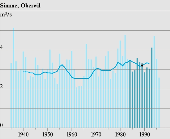
In contrast to floods, low flow can be described in terms of many characteristics. The legislative body decided to use the expression «Q347 flow rate». This flow rate corresponds to the quantity of water which is reached or exceeded in 95 % of cases and thus not reached in only 5 % of cases. In English-speaking areas Q347 is known as Q95. The map is based on a combination of information obtained from measurement sites and from points within the hydrographic network for which the Q347 flow rate was estimated by means of the acquired procedures. These estimation points are obtained where the network intercepts the limits of the so-called small catchments in map 1.2. For measurement stations, the Q347 flow rate for the standard period 1984 – 1993 and/or the operational period of the station is shown, depending on data availability. For the estimation points a flow rate is given which has been calculated using the described procedures and harmonised with the measurement stations.
In digital form:
Plate of the Atlas as pdf (6840kb)
Explanatory text (taken without changes from the Hydrological Atlas)
Table «Grundlage zur Bestimmung der Abflussmenge Q347»
Top (of page)