Hydrological Atlas of Switzerland – Plate 3.1²
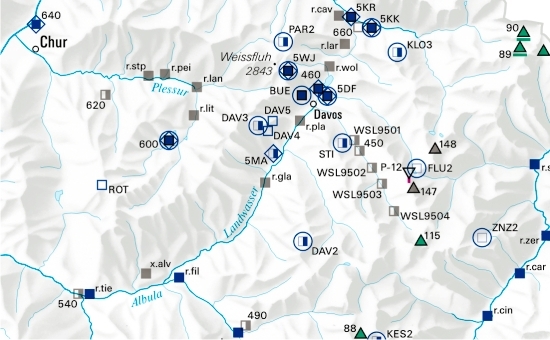
In Switzerland, snow measurements are carried out mainly at the measuring stations operated by the Swiss Federal Institute for Snow and Avalanche Research and the Swiss Federal Office of Meteorology and Climatology (MeteoSwiss). In addition, there are single stations and smaller measuring networks of a local character. The three most important snow characteristics dealt with in this plate are snow depth, new snow depth and snow water equivalent.
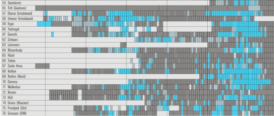
The glacier-measuring network is structured in such a way that it enables changes in glaciers to be analysed at both a global and a regional level. The monitoring programme includes annual records, or records covering a number of years, of changes in glacier length, mass and volume, flow speed and firn temperature, as well as the periodic recording of glacier characteristics.
Permafrost is an important indicator for environmental change at high altitudes, and research into this field has become more important over recent years. Together with the evaluation of periodic aerial surveys, the information obtained enables scientists to make a more accurate assessment of natural hazards originating in permafrost areas (e.g. processes causing mud-slides and rock-falls).
In digital form:
Plate of the Atlas as pdf (Edition 1992 / 25247kb)
Plate of the Atlas as pdf (Edition 2007 / 5547kb)
Explanatory text (taken without changes from the Hydrological Atlas)
Table «Schneemessnetze»
Table «Wichtigste schneerelevante Kenngrössen der Messnetze»
Table «Gletschermessnetze»
Table «Permafrostmessnetz»
Top (of page)